
 |
| My husband Steve and I as we enter through the West Glacier Entrance |
Some articles I have read recently call what
is happening to our planets glaciers as: “The Big Thaw”, “Twilight of the
Glaciers”, “Melting Away” and so on; trying to gain some readers attention.
They are all trying to explain what is happening to the world’s glaciers, and
they are right especially in Glacier National Park, glaciers are indeed receding
and melting away. Now as most anthropologist, scientist, and many know, yes are
world does go through climatic cycles and we have been in a unique period where
the temperatures have been relatively stable, but the temperature are going up
and the world is warming. Now that could be from human impacts, ocean current,
melting glaciers, and just a natural pattern from the earth’s location to the
sun. But whatever it is the warming temperatures are causing the glaciers
overall around the world to melt. I recently visited Glacier National Park for
my honeymoon and while there I noticed that there were hundreds of visitors and
even more then that there were not that many glaciers. So I asked myself why
was it called Glacier National Park? Where are all the glaciers? What is
causing this scare to the parks natural habitats? And why are so many Asian people
here? Now two of those questions I knew: the first was there are only a few
glaciers left and they must just be out of sight from the Going-to-the-Sun
Road and the second answer was Asian people have more money to travel and
the United States National Parks are awesome!
This semester at the University of Colorado at Denver my husband and I
wanted to take Glacial Geomorphology and it was in that class that I embarked
on finding out where the glaciers are, why it is called Glacier National Park,
and what will happen to the park in years to come.
 |
| https://www.e-education.psu.edu/files/geosc10/image/textbook%20images/Unit%207/map_Glacier.gif |
 |
| http://media.away.com/gifs/states/mt/m_glacie.gif |
 |
| Taken on the Going-to-the-Sun Road from West Glacier to Logan Pass visitors drive next to many snow packs and can park and walk to it from across the roadway. This snow pack is melting and a lot has to do with the season being midsummer (July) and I think also because of the dust and pollution from all the visitors driving along the road. This shows part of the Hanging Garden Falls. |
 |
| On Going-to-the-Sun Road at the bottom on the other side of Logan Pass going towards St. Mary. |
 |
| High amounts of water runoff on the road caused the lanes to go down to one. The day after this picture was taken there was a mudslide injuring several park visitors and the highway was closed for several days for clean up from July 17-19, 2012. |
 |
| The side of the road was laid in breaks that were laid in the 1930s. The engineering of the road also included holes in the road and small bridges so the runoff water could go under the road and not on flow over it. Allowing for visitors to drive during the runoff season. |
The topography
from the park has some to do with current glaciers, but mainly from former
glaciers from the Pleistocene. Research shows that the ice in the parks was
over a mile deep and there was enough ice in the Northern Hemisphere that the
sea level was 300 feet lower than it is today (NPS). The ice eventually
retreated and melted, but left behind beautiful topography. With many of the
mountains having arêtes, horns, ridges, cirques, moraines, and tarns. All of
these features are typical for alpine glacier and it is with that knowledge we
know many of these formations in the park happened thousands of years ago. Of the some 762 lakes in Glacier National Park many are tarns showing where a glacier made its way thought the valley. By knowing what a cirque is a way for glaciologist to determine mean annual air temperature was and how far it has retreated since the Pleistocene. By finding a cirque normally a lake (looking at current snowline) and where a lake is (looking at the Pleistocene snowline) you can determine the mean annual air temperature depression and then by using the present temperature minus the lapse rate (6 C/1000 m) you can determine what the mean annual temperature was in the Pleistocene. By looking at the USGS topography map of the Gable Mountain Quadrant and the Logan Pass Quadrant you can determine this. I found that the mean annual air temperature during the Pleistocene was 2.45 degree C lower. Now this is important in knowing that with just a few degrees difference in temperature the glaciers are critically impacted by warming weathers. Below is the data I collected.
|
Location
|
Cirque Lakes Pleistocene Snowline (in feet)
|
Current Snowline (in feet)
|
|
Gable Mountain Quadrant
|
6970
|
7240
|
|
Gable Mountain Quadrant
|
6990
|
7120
|
|
Logan Pass Quadrant
|
6560
|
6800
|
|
Logan Pass Quadrant
|
6200
|
7800
|
|
Logan Pass Quadrant
|
7270
|
7600
|
|
Many Glaciers Quadrant
|
7000
|
7360
|
|
Many Glaciers Quadrant
|
6632
|
7200
|
|
Many Glaciers Quadrant
|
6960
|
7200
|
|
Total Location= 8
|
Average elevation for Pleistocene snowline= 47,582/8= 5947.75 ft.= 1812.8742
Meters
|
Average elevation for current snowline= 58,320/8=7290 ft.= 2221.992 Meters
|
The Lapse rate 6˚C/ 1000 m x 409.1178m= 2.45˚C
The current mean annual air temperature for the park by
using the (NPS calculation of adding the average mean max and average mean low and
divided by 2) I got 40.78˚F= 4.88˚C.
4.88˚C-2.45˚C= 2.43˚C was the average mean temperature of Glacier National Park in the Pleistocene.
4.88˚C-2.45˚C= 2.43˚C was the average mean temperature of Glacier National Park in the Pleistocene.
|
Precipitation
|
Jan
|
Feb
|
Mar
|
Apr
|
May
|
Jun
|
Jul
|
Aug
|
Sep
|
Oct
|
Nov
|
Dec
| ||||||||||||
|
30 yr average
in inches |
3.40
|
2.37
|
1.86
|
1.81
|
2.57
|
3.28
|
1.75
|
1.64
|
2.06
|
2.33
|
3.10
|
3.30
| ||||||||||||
|
30 yr low
in inches |
0.16
|
0.33
|
0.43
|
0.27
|
0.91
|
0.75
|
0.00
|
0.00
|
0.02
|
0.08
|
0.65
|
0.68
| ||||||||||||
|
30 yr high
in inches |
7.07
|
5.10
|
4.13
|
3.45
|
6.13
|
6.94
|
5.11
|
5.14
|
6.17
|
5.87
|
7.53
|
7.72
| ||||||||||||
|
Ave number of days with precipitation over 0.01 inches
(rain and/or snow) |
17
|
13
|
13
|
11
|
13
|
13
|
9
|
9
|
9
|
11
|
15
|
17
| ||||||||||||
|
Average Snowfall
in inches |
39.6
|
22.5
|
14.5
|
3.5
|
0.4
|
0.2
|
0
|
0
|
0.1
|
2.0
|
17.2
|
37.5
| ||||||||||||
|
Temperature
|
Jan
|
Feb
|
Mar
|
Apr
|
May
|
Jun
|
Jul
|
Aug
|
Sep
|
Oct
|
Nov
|
Dec
| ||||||||||||
|
Average Max
|
28.5
|
34.7
|
41.9
|
52.9
|
64.1
|
71.2
|
79.1
|
78.1
|
66.7
|
52.7
|
37.3
|
30.0
| ||||||||||||
|
Average Min
|
14.9
|
18.8
|
22.9
|
29.7
|
37.1
|
43.7
|
47.2
|
46.3
|
38.8
|
31.8
|
24.9
|
18.4
| ||||||||||||
|
Maximum High
|
50
|
58
|
66
|
83
|
90
|
91
|
99
|
99
|
95
|
77
|
65
|
52
| ||||||||||||
|
Maximum Low
|
-35
|
-32
|
-30
|
3
|
13
|
24
|
31
|
26
|
18
|
-3
|
-29
|
-36
|
This is a table from the National Park Service from Glacier National Park
As we know
temperatures are indeed rising the mean temperature going up by a few degrees
each year will cause many glaciers to melt. This is why many scientist believe
all the glaciers in the park will be gone by 2020. Research has been conducted on Swiftcurrent
Lake using ice cores to determine the geomorphic and climate change over 12,900
years. Kelley MacGregor et al found that underlining Swiftcurrent Lake were
tills from the Pleistocene that were 1 to 3 meters thick. They were able to
take cores from the till and measured x-ray diffraction, grain size, carbon
coulometry, and Carbon and Nitrogen elemental analysis in order to link climate
and solar forces on a centennial timescale to the climate proxies and alpine
geomorphic processes. This will help
with further studies on knowing the links between climate, solar proximity, and
glaciers to help understand past and future glaciations. It also showed that
there is a significant link to global warming and melting glaciers.
 |
| Lake McDonald Valley, we were able to rent a small 8 speed motor boat and go around the deep lake. The lake was 500 feet deep and very cold. The lake was incredibly clear it looked like you could swim to the bottom when it was over 20 feet deep. The lake is about 10 miles long and is the largest lake in the park. The glaciers that formed this lake carved large hanging valleys and there are now many waterfalls along several trails from the lake. |
As I said before when documented in 1850 there were over 150 glaciers that covered Glacier National Park’s mountains, of which 36 were named. Of those now there are just barely 25 glaciers remain. In order to be classified as a glacier the glacier most be 25 acres after which the moving glacier will just start to slowly melt away. On April 16th, USA Today reported that Miche Wabun and Shepard Glacier fell below that 25 acre mark and are no longer “classified” as glaciers, they each receded by approximately 55% since the 1960s. Below is a picture of the Shepard Glacier over a 95 year life span by the USGS. The article also stated that even though temperatures are still relatively cold the average temperature from 2000-2009 was 2 degrees warmer then it was in the 1950-1979. . National Geographic in “The Big Thaw” reported that Sperry Glacier has receded over 800 acres and now is only covering roughly 250 acres. There is also a picture of Sperry Glacier below of a then an now taken from the USGS. The largest remaining glacier is Harrison Glacier which is only 465 acres. By 2020 there are some scientist who believe all the glaciers in the park will be gone. This is a fact we must face in today’s society, but what will be the affects to the park, wildlife, and surrounding areas?
The climate research done linking climate change to glacial retreating and its effects on alpine invertebrates proves that there will be effects to the biology as a result from glaciers melting out. The original research conducted by Clint Mulfeld et al shows the melting glaciers will have an impeding effect on biological life in the park. Their specific data looked at the alpine stream biota change based on climate warming overall and how it is going to affect invertebrate that live on the glacier melt such as the Lednia tumana a meltwater stonefly. Their research was able to show that 86% of the species lived within a 305-480 m from a glacier or permanent snow field. It said that the remaining 14% lived within 235-287m below an alpine spring. Their conclusion was that if there was no longer an ice field and/ or glacier present it would threaten the existence of the species. It is not only a fly that is endanger (this was just a great research conducted), but many other animals and wildlife need glaciers and permanent snowfields in order to survive. The grizzle bear is a great example: As the bear awakes from hibernation it immediately starts to eat. It eats berries and fish primarily. Now many glaciers as they advance create open space and once they retreat bushes begin to form there. The seasonal runoff allows for fish to swim in the high rivers. According to the NPS website “The historic assemblage of fish species in Glacier National Park is restricted in number due to the relatively recent withdrawal of continental glaciers from the region.” Many grizzly bears live in mountainous regions where there is open berry bush fields and rivers containing migrating fish if the glaciers are not allowing fish to migrate and more trees to grow the bears will be forced to move so they can find food. Currently in the park there are 60 species of mammals there are 4 federally listed endangered species: bald eagle, grizzly bear, lynx, and the bull trout. The grey wolf and the slender moonwort are both being considered for the federal endanger species list as well (nps). These species are threatened by growing populations and have a safe haven in the park. Due to warming temperature and invasive species how will these species fight to exist in coming years if they are already struggling to exist? Are they at the end of their time? Many questions are being raised by the park rangers and local and federal conservationist to conduct more research on the effects of the glaciers melting in the park.
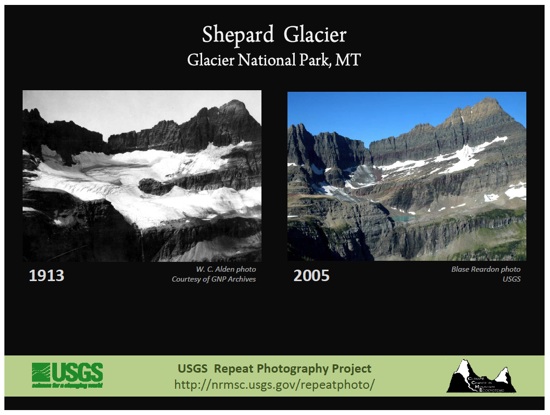 |
| Showing the retreat of the Shepard Glacier over 95 years. Shepard Glacier is no longer listed as a glacier in the park because it no longer cover 25 acres. Source: USGS from site-http://www.nationalparkstraveler.com/2010/04/climate-change-continues-melt-glacier-national-parks-icons5669 |
 |
| Showing the change in the Sperry Glacier over 95 years. Sperry Glacier currently is under 250 acres. Source: USGS from site-http://www.nationalparkstraveler.com/2010/04/climate-change-continues-melt-glacier-national-parks-icons5669 |
 |
| Mountain Goat on the highway side after Logan Pass |
 |
| Mountain Sheep at the top of Logan Pass. Generally non aggressive, but because of high amounts of visitors the sheep are going up to picnic goers and stealing their food. This one was running away from a family that it was trying to steal from. |
 |
| This Marmot was also at the top of Logan Pass watching the visitors walk by. I stopped to look and many thought it was a rock (even my husband) until we got about 20 feet away and it started to move. This entire area was once covered by the Logan Glacier |
The impacts to
the park is obviously going to be on the wildlife that lives there, but also to
the employees and the visitors. Many of the seasonal employees are hired for the
summer when many visitors come to see the glaciers and the variety of wildlife
that lives there. But with the glaciers melting away and the impacts it could
have on the diverse biology how is that going to impact the parks visitors?
This is an unknown question, but with resent budget cuts to national parks why
would they hire more park rangers if they are not needed to conduct hiking
tours to the glaciers. It is not just park rangers, but many of the local
businesses that’s primary business is on the river. During the high runoff from roughly spring to fall many companies have rafting and kayaking tours. Some USGS employees believe that the season will be cut
significantly (watch the video below). Over the summer we saw that the rivers
were still flowing at incredible amounts, but the glaciers above as they melt
are eventually not going to distribute the same amount of water as they
currently are. There were 4 companies listed on the NPS site and there were
many more companies that work outside the park that are all raft/ kayaking
companies. All which will be impacted by lower water levels to come. Here in
Colorado we saw that over this summer (2012) many rafting companies were
struggling to stay open and launch because the water levels were extremely low.
For my bachelorette party we tried going to Idaho Springs, CO for a raft tour at the end of June, the company told us that water were too low to launch and they are not able
to take groups out for tours. What an impact that has on the companies income and decisions on how
they will hire in the future. How are all these companies in Glacier going to handle such a short
rafting season? Now there will still be visitors who go climbing and such in
the park and that maybe the way to go for some businesses. But employees and locals are considered
about the unknown. For me it is such a ways out and boring drive going to
Glacier National Park and many may think that too. So parks that have more amenities
and features like Yellowstone, Yosemite, and even Rocky Mountain National Parks
many become more popular.
 |
| This is Oberlin Mountain showing the Bird Woman Falls which is the largest falls in the park. |
The social
impacts to the surrounding areas will be enormous not just locally, but around
the United State. The glaciers in Glacier National Park can be split into 3 main
direction (NPS). They are the headwaters to stream/ rivers that go to the Atlantic,
Pacific, and Hudson Bay watersheds. The runoff from Glacier is at such high
rates that the USGS has been monitoring it for over half a century. With the
glaciers melt going into several tributaries the water from these glaciers are
typically captured before they reach the oceans. They are then in dams, lakes,
and rivers that help supply water to people and for agricultural uses as well.
Montana also known for their big skies and rolling hills -- has many ranches and use high amount
of water for agriculture. Many of the locals use the water from the runoff to irrigate
their land. With glaciers melting they will have less of an open time for
irrigation, they will have less water privileges, and a different grow season. Below is a Youtube
video from the USGS Multimedia Gallery that talks about many of the impacts I
have talked about. Questions asked from visitors and locals from Glacier
National Park and answered by employees from the US Geological Survey.
References:
Muhlfeld , Clint C. , Joseph Giersch, et al.
"Climate Change." Climate Change. 106.2 (2011): 337-345.
Print. (Muhlfeld , Giersch, and et al
337-345)MacGregr, Kelly, Catherne Riihimaki, et al. "Quaternary Research." Quaternary Research. 75.1 (2011): 80-90. Print.
Glick, Daniel. "GeoSigns: The Big Thaw." National Geographic . 2004: n. page. Web. 22 Oct. 2012. http://ngm.nationalgeographic.com/ngm/0409/feature2/fulltext.html .
Appenzeller, Tim. "The Big Thaw." National Geographic. 2007: n. page. Web. 22 Oct. 2012. http://ngm.nationalgeographic.com/2007/06/big-thaw/big-thaw-text .
Nash, Stephen. "Twilight of the Glaciers." New York Times [New York] 29 Jul 2011, U.S. Edition Travel. Web. 25 Oct. 2012.
Brown, Matthew. "Two more glaciers gone from Glacier National Park." USA Today [McLean, Va] 07 Apr 2010, n. pag. Web. 25 Nov. 2012. http://usatoday30.usatoday.com/tech/science/environment/2010-04-07-glacier-national-park_N.htm .
Phelan, Glen. "Melting Away." National Geographic. 2005: 4-9. Web. 25 Nov. 2012. http://magma.nationalgeographic.com/ngexplorer/0501/articles/mainarticle.html .
Higgins, Nadia. Welcome to Glacier National Park. Chanhassen: The Child's World, 2007. Print.
Lomax, Becky. Moon Glacier National Park. 3rd Edition. Berkeley: Avalon Travel, 2011. Print.
Additional Resource sites:
Nation Park services Glacier website: http://www.nps.gov/glac/index.htm
US Geological Service: http://www.usgs.gov; http://nrmsc.usgs.gov/research/glacier_retreat.htm; http://gallery.usgs.gov/videos/528
Pictures
Many are my pictures from my trip to Glacier from July 15-16;20-22, 2012
US
map with glacier: https://www.e-education.psu.edu/files/geosc10/image/Textbook%20images/Unit%207/map_Glacier.gif
Glacier map: http://media.away.com/gifs/states/mt/m_glacie.gif
Boulder Glacier then and now: http://www.nps.gov/glac/parknews/blogs_ollig_0908.htm
Sperry and Shepard Glacier then and now: http://www.nationalparkstraveler.com/2010/04/climate-change-continues-melt-glacier-national-parks-icons5669
Youtube:
The park: http://www.youtube.com/watch?v=SeRtZpRAIkM
Melting Away: http://www.youtube.com/watch?v=7DZPs-JPKak
USGS Question/Answer http://gallery.usgs.gov/videos/528
No comments:
Post a Comment